Tropical Cyclone Risk Assessment Model
Country
Philippines
Language
English
Authors
Miguel Adrian Garcia, Gerson Hubert Aquino
Project Summary
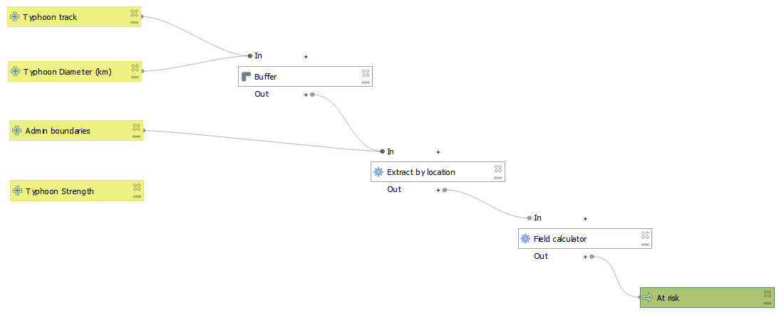
The project is a Risk Assessment Model which follows the Risk Formula, Risk = Hazard X Vulnerability X Exposure, to compute the risk score and corresponding activation level for a Tropical Cyclone. The model utilizes population data, poverty indices, and tropical cyclone intensity as its variables for Exposure, Vulnerability, and Hazard, respectively. Using these set of variables, the model will compute the risk scores of specific provinces/boundaries which determines the activation level for a Tropical Cyclone affecting the country.
Tools
Theme Keywords
Algorithms
Datasets
administrative boundary: https://github.com/benhur07b/phl-admin-psgc population layer: Philippine Statistics Authority poverty indices: Philippine Statistics Authority (https://psa.gov.ph/poverty-press-releases/nid/162559) population density: High Resolution Settlement Layer (https://data.humdata.org/dataset/philippines-high-resolution-population-density-maps-demographic-estimates) tropical cyclone tracks (GONI): NIII JP (http://agora.ex.nii.ac.jp/digital-typhoon/year/wnp/2020.html.en)
Bataan Barangays Most Exposed to Flood
Country
Philippines
Language
English
Authors
Patricia Anne Delmendo, Jericho Mendoza
Project Summary
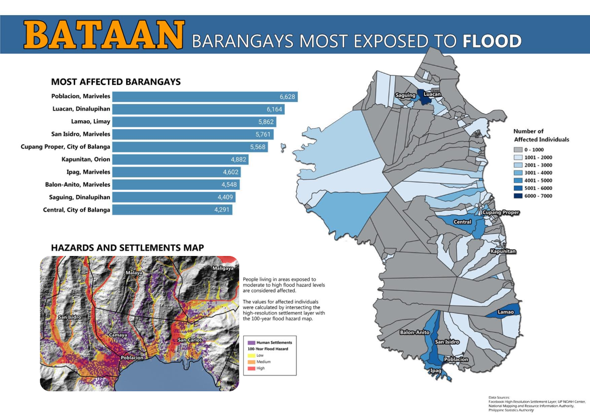
In the Philippines, the University of the Philippines Resilience Institute (UPRI) combined Meta’s High Resolution Settlement Layer (HRSL) with recent census data (2020) of the province of Bataan in order to generate an updated settlement area and population density map layer of the province. Using this updated population layer, UPRI was able to calculate and present the flood-hazard exposed population in the different barangays of the province.
Tools
Theme Keywords
Algorithms
Datasets
digital elevation model: IfSAR administrative boundary: PhilGIS population density: HRSL flood hazard: UP NOAH Center
Family farming
Country
Brazil
Language
English
Authors
Agmerson Bruno, Marcus Boente
Project Summary
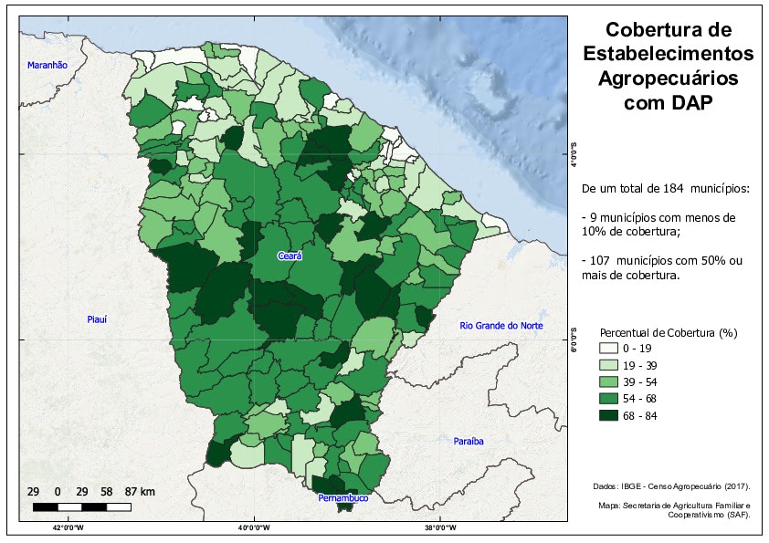
The project explores the relevance of family farming for Brazil using official data.
Tools
Theme Keywords
Algorithms
Datasets
agricultural census, Declaration of Aptitude to PRONAF, administrative boundary
Rural Credit
Country
Brazil
Language
English
Authors
Eduardo Marcusso
Project Summary
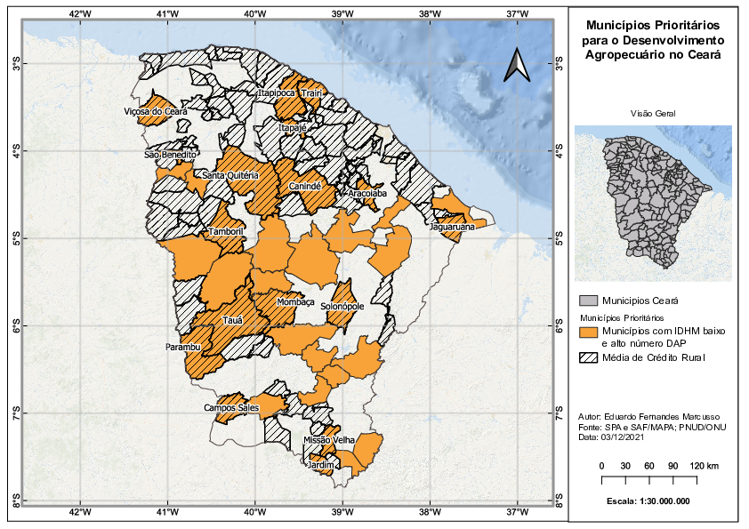
The project uses several sources of spatial data to study the State of Ceará based on data from Human Development Index, official licenses, and rural credit. We have merged them and created analysis, knowledge, and territorial intelligence to support MAPA's public policy.
Tools
Theme Keywords
Algorithms
Datasets
Shapefiles of Brazilian states, Cities boundaries in Ceará, Municipal Human Development Index for Brazilian Cities, Rural credit, Declaration of Aptitude to PRONAF (National Program for Strengthening Family Agriculture)
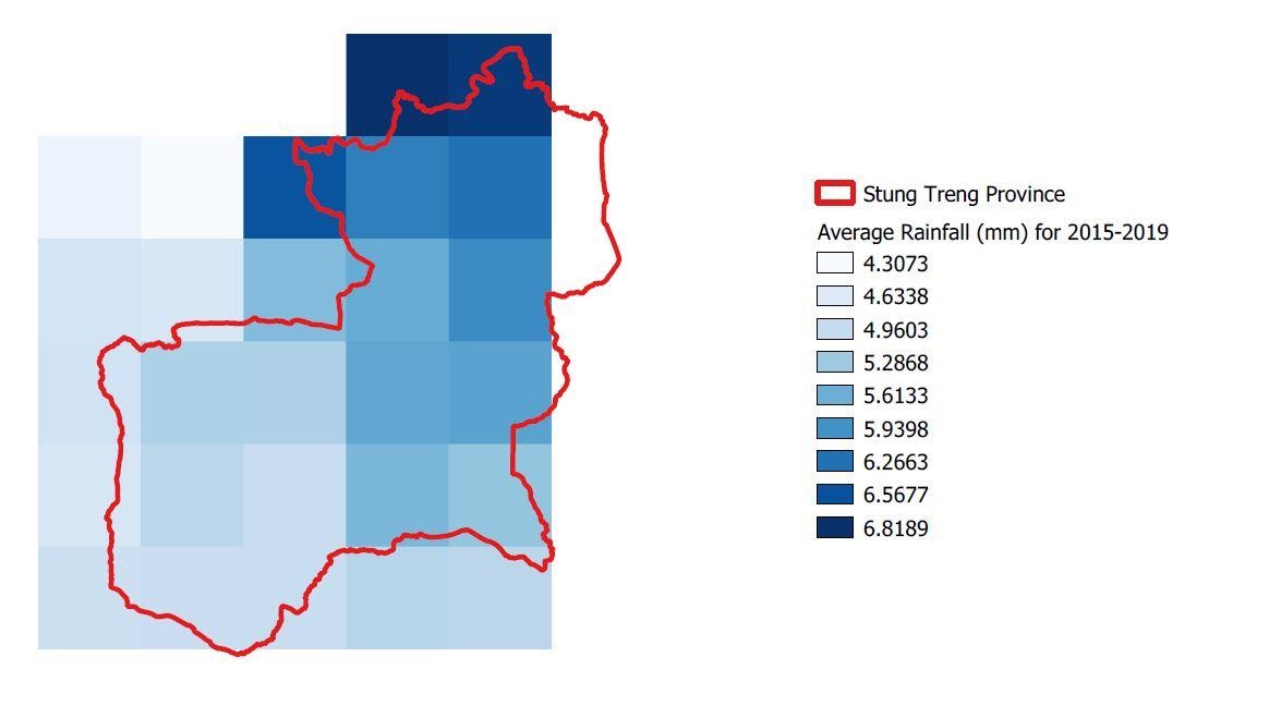
Precipitation in Stung Treng province, Cambodia
Country
Cambodia
Language
English
Authors
Cambodia National Mekong Committee
Project Summary
Strung Treng province is one of the important provinces in the Mekong basin of Cambodia, since RAMSAR site is located in the province. As climate change is very sensitive, the pilot project may tell us some change of precipitation during the period of time from 2015 to 2019, and could see the trend of rainfall in the future
Tools
Theme Keywords
Algorithms
Datasets
GADM
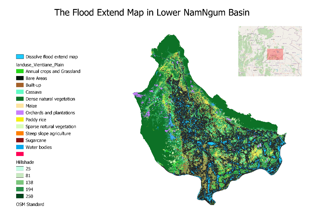
Flood Risk Assessment Map of NamNgum Basin, Laos
Country
Lao PDR
Language
English
Authors
Malabou Baylatry, Soukphaphone Soodtharavong, Soutvilay Douangphachan, Oudomsak Bounmanivanh
Project Summary
Our project was about generating the flood extend map in lower Namngum basin and calculating the risk area of land use in mentioned basin.
Tools
Theme Keywords
Algorithms
Datasets
DEM, flood hazard, administrative boundary, land use
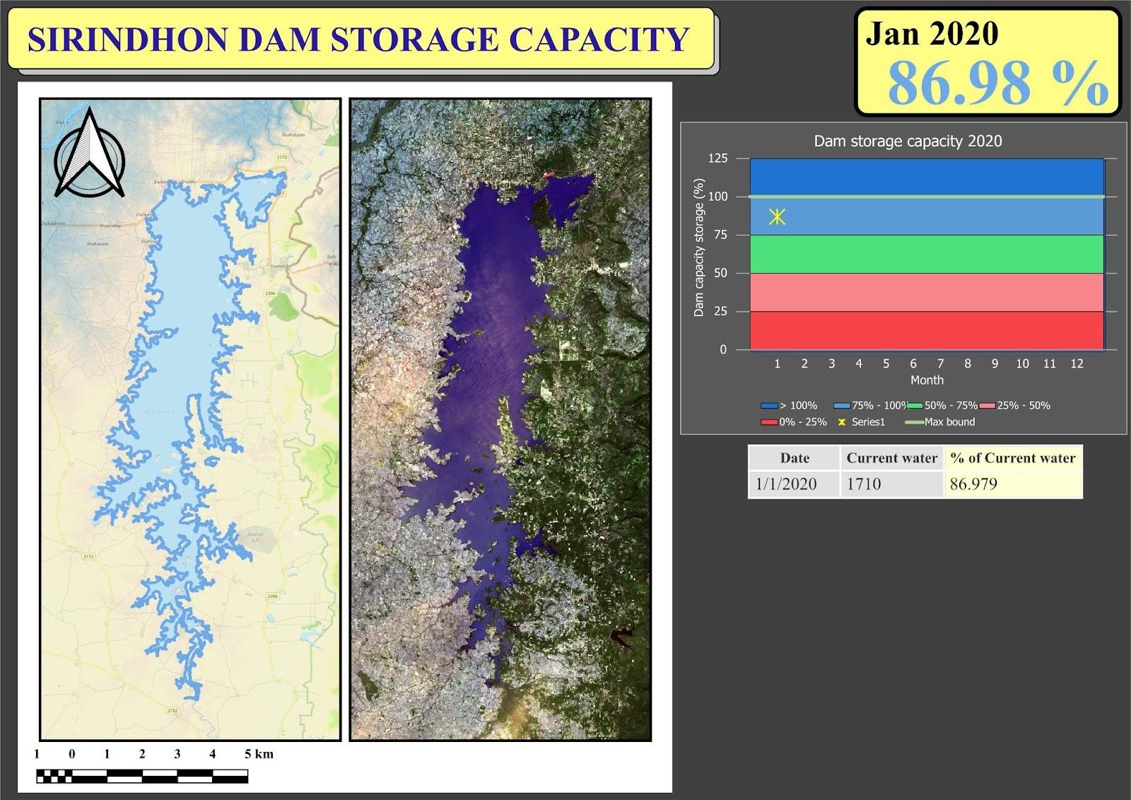
Sirindhorn Dam Storage Capacity
Country
Thailand
Language
English
Authors
Peraya Tantianuparp, Suluk Chaikhan
Project Summary
This project aims to monitor capacity and show monthly water extent of Sirindhorn reservoir in 2020 using map visualization and analytical data. The project can be applied with other reservoirs and related projects in the future.
Tools
Theme Keywords
Algorithms
Datasets
SRTM DEM, Sentinel-1, Sentinel-2, water volume, reservoir boundary
Source code available under the MIT license.
Content on this site, made by Open Knowledge Foundation, is licensed under a Creative Commons Attribution 4.0 International License.
Refer to our attribution page for attributions of other work on the site.